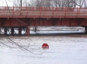
 As the Red River’s water levels rise, the idea of snow melting and water levels rising area a concern for many this spring.
In response, many along the Red River are prepared or preparing for a potential impact of spring flooding.
The National Weather Service (NWS) and Advanced Hydrologic Prediction Service have compiled a list of various effects on the area as the river’s levels increase, including the flooding of Wells Park at 16.5 feet, which indicates a Major Flood.
At 15 feet, storm sewer outlets and Main Street are closed in Wahpeton, while at 13.5 feet, North Main Street and the bridge are closed in Breckenridge, indicating a Moderate Flood.
At 12 feet, storm sewer valves are closed, and interior pumping begins in Breckenridge, while the Otter Tail River water starts to flow into the Breckenridge Diversion at 11.6 feet.
When the river reaches 11 feet, it indicates a Minor Flood. At 9.5 feet, it is considered the Action Stage/Forecast Service Stage, while at 8 feet, the Otter Tail River begins to overflow downstream of the Highway 75 bridge.
When the water levels reach 7 feet, the storm sewer outfalls are closed. At 22.5 feet, the top of the permanent dike is reached, while at 18 feet, dike openings at Minnesota St (MN) and Dakota St (ND) are closed, and dike openings at the railroad bridge require the removal of railroad tracks.
During the Record Flood at 17.5 feet, Fargo-Moorhead mobilizes as patrolling of levees and storm sewer outlets begins.
The Post-Diversion Flood of Record (March 24, 2009), and Post-1900 Flood Flow of Record (10.4 kcfs on March 24, 2009), occurred at this level.
In response to the growing threat of flooding, the City of Fargo has been strategically developing a series of flood control projects to safeguard its residents and infrastructure.
By prioritizing the installation of permanent flood control features, such as levees, floodwalls, drainage enhancements, and increased pumping capacity, the City aims to reduce its reliance on temporary emergency measures and build a more flood-resilient community.
These permanent flood control features offer a more stable solution compared to rapid-deploy flood fighting activities, which often need to be purchased, transported, placed, removed, and discarded.
Detailed information on specific projects can be found on the City’s website.
In addition to these projects, the City of Fargo has launched the Flood Protection Incentive Program (FPIP) to encourage homeowners along the primary line of protection to invest in rear yard flood protection.
Eligible property owners can apply for reimbursement of associated costs through the program.
More information on FPIP and eligibility requirements can be obtained by contacting the Engineering Department or sending an email.
As part of its flood control strategy, the City of Fargo has also been buying out and removing properties in high-risk flood-prone areas since 1997.
With more than 200 properties purchased and removed to date, this initiative strengthens the primary line of protection and reduces the need for emergency measures.
The City of Fargo’s floodplain management practices extend beyond specific flood mitigation projects.
All aspects of residential and commercial developments, roadways, and water and sewer systems undergo review for floodplain impact to ensure a comprehensive approach to flood preparedness.
By integrating these practices in infrastructure design and planning, the City of Fargo is committed to building a more flood-resilient community for its residents.
As the Red River rises, Fargo-Moorhead prepares for the impact.
The National Weather Service (NWS) and Advanced Hydrologic Prediction Service have compiled a list of various effects on the area as the river’s levels increase.
At the Action Stage (17+ feet), the water is expected to rise to the edge of the bike path at El Zagal bowl along Elm Street North between 14th and 15th Avenue North (Fargo). When the river reaches Minor Flooding (18+ feet), Elm Street between 14th and 15th Avenue North is closed, and storm sewer pump stations are beginning to operate in Fargo. At 19 feet, the low-level dam south of Main Avenue is underwater.
By the time the river reaches 21 feet, the 3rd Street underpass is closed in Moorhead, and at 22 feet, the North Broadway Bridge is closed in Fargo-Moorhead. When the water levels reach 23 feet, the North Broadway bridge floods.
At Moderate Flooding (25+ feet), the city parks and recreation areas along the river in Fargo begin to flood, and all storm sewer lift stations are in operation. When the river reaches 28 feet, the 12th Avenue North/15th Avenue North bridge over Red River is closed in Fargo-Moorhead.
When Major Flooding (30+ feet) is reached, the 1st Avenue North underpass is closed in Moorhead, and at 32 feet, removable floodwalls are installed along 2nd Street in Fargo, and the First Avenue North bridge across Red River is closed. At 33 feet, Wall Street Avenue North is closed in Moorhead, and at 34 feet, the Northern Pacific Avenue (Fargo)/Center Ave (Moorhead) bridge clearance is closed.
When the river reaches 36 feet, sandbagging starts in Fargo if the river is forecast to rise above 38 ft. At 37 feet, the Convent Bridge at 52nd Avenue South is closed in Fargo, and Oakport Street North is closed near 50th Avenue North in Moorhead. At 38 feet, 28th Avenue North is closed at Ditch #41 in Moorhead, and at 38.5 feet, 11th Street North is closed near 28th Avenue North in Moorhead.
At 39 feet, the 36th Street South bridge and 40th Avenue South bridge over Drain 27 closes in Fargo, and at 40 feet, the 25th Street South bridge over Rose Coulee closes in Fargo. The river’s record flood of 40.82 feet was recorded on March 28, 2009, in an instantaneous measurement.
Residents in Fargo-Moorhead are advised to take the necessary precautions as the river continues to rise, with the NWS and Advanced Hydrologic Prediction Service closely monitoring the situation.
In the Minneapolis/St. Paul area, the Twin Cities National Weather Service has issued an updated spring flooding forecast, warning of above-normal flooding in the upper Mississippi, Minnesota, and Chippewa River basins.
Minnesota officials are urging residents to prepare by obtaining flood insurance, assembling emergency kits, and developing evacuation plans.
During a flood, residents should follow local authorities’ instructions, practice electrical safety, and avoid floodwaters.
After a flood, they should prioritize safety, document and report damages for recovery.
Resources on flood preparedness, response, and recovery are available from the Minnesota Department of Public Safety, the National Weather Service, and the Department of Natural Resources.