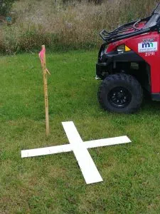
Example of aerial “X” target. (MnDOT)
Battle Lake, MN – The Minnesota Department of Transportation is asking people not to disturb aerial photography targets as crews begin aerial mapping two highways.
Starting this month (April), MnDOT will be surveying Highway 78, from north of Ottertail to Highway 210 in Battle Lake, and Highway 75, from north of Graceville to Highway 12 in Ortonville.
MnDOT Public Affairs Coordinator Emma Olson says the survey process relies on clear observations and must be conducted after the snow has melted and before the trees leaf out. In order to obtain accurate aerial mapping, Olson says crews paint large white “X” targets on paved surfaces, and place plastic or fabric targets on unpaved surfaces. The plastic and fabric targets are temporary and will be removed when photography is complete.
MnDOT requests that landowners not remove or disturb the targets until the photography is complete. If a target must be moved, contact District 4 surveys at 218-849-2435 or email jeremy.erickson@state.mn.us.
Olson says aerial mapping is used to create a record of existing infrastructure and landscape for transportation planning and highway design.


